
Pantanal topographic map
Interactive map
Click on the map to display elevation.
About this map
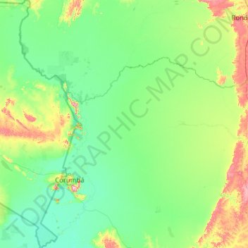
Name: Pantanal topographic map, elevation, terrain.
Average elevation: 499 ft
Minimum elevation: 253 ft
Maximum elevation: 3,097 ft
Other topographic maps
Click on a map to view its topography, its elevation and its terrain.
Berenice
Brazil > Mato Grosso do Sul > Corumbá
Berenice, Nhecolândia, Corumbá, Região Geográfica Imediata de Corumbá, Região Geográfica Intermediária de Corumbá, Mato Grosso do Sul, Central-West Region, Brazil
Average elevation: 358 ft