
Capitol Reef National Park topographic map
Interactive map
Click on the map to display elevation.
About this map
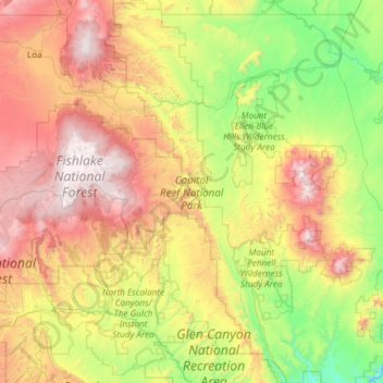
Name: Capitol Reef National Park topographic map, elevation, terrain.
Average elevation: 6,440 ft
Minimum elevation: 3,671 ft
Maximum elevation: 11,430 ft
Other topographic maps
Click on a map to view its topography, its elevation and its terrain.
Hite Point
United States > Utah > Garfield County
Hite Point, Garfield County, Utah, United States
Average elevation: 4,423 ft
Cannonville
United States > Utah > Garfield County
Cannonville, Garfield County, Utah, 84718, United States
Average elevation: 6,214 ft
Panguitch Lake
United States > Utah > Garfield County
Panguitch Lake, Garfield County, Utah, United States
Average elevation: 8,294 ft
Bryce Canyon National Park
United States > Utah > Garfield County
Bryce Canyon National Park, Garfield County, Utah, United States
Average elevation: 7,411 ft
Upper Calf Creek Fall
United States > Utah > Garfield County
Upper Calf Creek Fall, Garfield County, Utah, 84716, United States
Average elevation: 6,247 ft
Piracy Point
United States > Utah > Garfield County
Piracy Point, Bryce Canyon Scenic Drive, Garfield County, Utah, United States
Average elevation: 8,369 ft
Henderson Creek
United States > Utah > Garfield County
Henderson Creek, Garfield County, Utah, 84776, United States
Average elevation: 6,617 ft
Antimony
United States > Utah > Garfield County
Antimony, Garfield County, Utah, 84712, United States
Average elevation: 6,762 ft
Bryce Canyon
United States > Utah > Garfield County > Tropic
Bryce Canyon, Tropic, Garfield County, Utah, United States
Average elevation: 7,372 ft
Escalante
United States > Utah > Garfield County
Escalante, Garfield County, Utah, 84726, United States
Average elevation: 5,843 ft
Hatch
United States > Utah > Garfield County
Hatch, Garfield County, Utah, 84735, United States
Average elevation: 7,005 ft
Bryce Canyon City
United States > Utah > Garfield County > Bryce Canyon City
Bryce Canyon City, Garfield County, Utah, 84764, United States
Average elevation: 7,667 ft
Panguitch
United States > Utah > Garfield County > Panguitch
Panguitch, Garfield County, Utah, 87459, United States
Average elevation: 6,827 ft
Andy Miller Flats
United States > Utah > Garfield County
Andy Miller Flats, Garfield County, Utah, United States
Average elevation: 5,262 ft
Panguitch
United States > Utah > Garfield County
Panguitch, Garfield County, Utah, United States
Average elevation: 6,703 ft