
Wedza topographic map
Interactive map
Click on the map to display elevation.
About this map
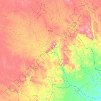
Name: Wedza topographic map, elevation, terrain.
Location: Wedza, Mashonaland East Province, Zimbabwe (-19.12571 31.19691 -18.41039 31.98539)
Average elevation: 4,180 ft
Minimum elevation: 2,680 ft
Maximum elevation: 5,869 ft
Other topographic maps
Click on a map to view its topography, its elevation and its terrain.
Chinanga
Zimbabwe > Mashonaland East Province > Goromonzi
Chinanga, Goromonzi, Mashonaland East Province, Zimbabwe
Average elevation: 4,708 ft
Imire Rhino and Wildlife Conservation Wilderness
Zimbabwe > Mashonaland East Province > Wedza
Imire Rhino and Wildlife Conservation Wilderness, Wedza, Mashonaland East Province, Zimbabwe
Average elevation: 4,649 ft
Nyagui
Zimbabwe > Mashonaland East Province > Goromonzi
Nyagui, Goromonzi, Mashonaland East Province, Zimbabwe
Average elevation: 4,275 ft