
Sileby topographic map
Interactive map
Click on the map to display elevation.
About this map
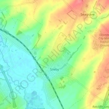
Name: Sileby topographic map, elevation, terrain.
Location: Sileby, Charnwood, Leicestershire, England, United Kingdom (52.72005 -1.13388 52.75677 -1.07061)
Average elevation: 226 ft
Minimum elevation: 138 ft
Maximum elevation: 361 ft
Other topographic maps
Click on a map to view its topography, its elevation and its terrain.
Shepshed
United Kingdom > England > Leicestershire > Charnwood
Shepshed, Charnwood, Leicestershire, England, United Kingdom
Average elevation: 364 ft
Loughborough
United Kingdom > England > Leicestershire > Charnwood
Loughborough, Charnwood, Leicestershire, England, LE11 5BJ, United Kingdom
Average elevation: 200 ft