
Yangambi topographic map
Interactive map
Click on the map to display elevation.
About this map
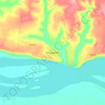
Name: Yangambi topographic map, elevation, terrain.
Location: Yangambi, Tshopo, Democratic Republic of the Congo (0.72583 24.43336 0.80583 24.51336)
Average elevation: 1,342 ft
Minimum elevation: 1,194 ft
Maximum elevation: 1,594 ft
Other topographic maps
Click on a map to view its topography, its elevation and its terrain.
Yata
Democratic Republic of the Congo > Tshopo
Yata, Tshopo, Democratic Republic of the Congo
Average elevation: 1,237 ft
Kisangani
Democratic Republic of the Congo > Tshopo
Kisangani, Tshopo, Democratic Republic of the Congo
Average elevation: 1,362 ft
Tshopo
Democratic Republic of the Congo > Tshopo
Tshopo, Democratic Republic of the Congo
Average elevation: 1,736 ft