
Talbot Island topographic map
Interactive map
Click on the map to display elevation.
About this map
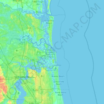
Name: Talbot Island topographic map, elevation, terrain.
Location: Talbot Island, Jacksonville, Duval County, Florida, USA (30.16274 -81.76092 30.80274 -81.12092)
Average elevation: 10 ft
Minimum elevation: -13 ft
Maximum elevation: 105 ft
Other topographic maps
Click on a map to view its topography, its elevation and its terrain.
Julington Creek
USA > Florida > Jacksonville
Julington Creek, Jacksonville, Duval County, Florida, 32258, USA
Average elevation: 20 ft
Fort George Island
USA > Florida > Jacksonville
Fort George Island, Jacksonville, Duval County, Florida, 32228, USA
Average elevation: 10 ft
Big Island Swamp
USA > Florida > Jacksonville
Big Island Swamp, Tropea Way North, The Jaxon Apartments, Jacksonville, Duval County, Florida, 32246-6624, USA
Average elevation: 36 ft
Timucuan Ecological & Historic Preserve
USA > Florida > Jacksonville
Timucuan Ecological & Historic Preserve, Big Talbot Island State Park Trail, Jacksonville, Duval County, Florida, USA
Average elevation: 7 ft
Burton Island
USA > Florida > Jacksonville
Burton Island, Jacksonville, Duval County, Florida, USA
Average elevation: 20 ft
Big Talbot Island State Park
USA > Florida > Jacksonville
Big Talbot Island State Park, Jacksonville, Duval County, Florida, USA
Average elevation: 7 ft