
Kitasaku County topographic map
Interactive map
Click on the map to display elevation.
About this map
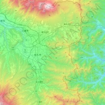
Name: Kitasaku County topographic map, elevation, terrain.
Location: Kitasaku County, Nagano Prefecture, Japan (36.08634 138.23387 36.42439 138.65716)
Average elevation: 3,196 ft
Minimum elevation: 1,027 ft
Maximum elevation: 8,399 ft
Other topographic maps
Click on a map to view its topography, its elevation and its terrain.
国合同庁舎
Japan > Nagano Prefecture > Iida > 国合同庁舎
国合同庁舎, Iida, Nagano Prefecture, 395-0031, Japan
Average elevation: 1,680 ft