
Southbroom topographic map
Interactive map
Click on the map to display elevation.
About this map
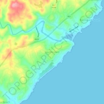
Name: Southbroom topographic map, elevation, terrain.
Average elevation: 98 ft
Minimum elevation: -3 ft
Maximum elevation: 413 ft
Southbroom is located on a gentle hilly topography overlooking the Indian Ocean approximately 23 km south-west of Port Shepstone and 18 km north-east of Port Edward. It is situated between Ramsgate in the north and Marina Beach in the south.
Other topographic maps
Click on a map to view its topography, its elevation and its terrain.
Ivy Beach
South Africa > KwaZulu-Natal > Ugu District Municipality > Hibiscus Coast Local Municipality > Leisure Bay > Ivy Beach
Ivy Beach, Hibiscus Coast Ward 1, Leisure Bay, Hibiscus Coast Local Municipality, Ugu District Municipality, KwaZulu-Natal, South Africa
Average elevation: 69 ft