
New Albany topographic map
Interactive map
Click on the map to display elevation.
About this map
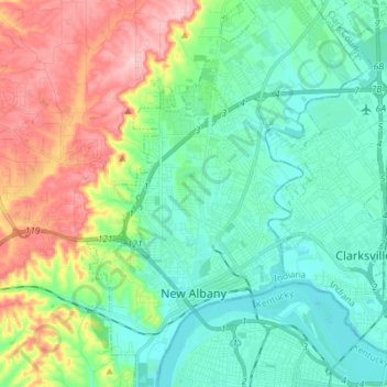
Name: New Albany topographic map, elevation, terrain.
Location: New Albany, Floyd County, Indiana, 47150, United States (38.25777 -85.86439 38.37192 -85.78295)
Average elevation: 591 ft
Minimum elevation: 407 ft
Maximum elevation: 1,014 ft
Other topographic maps
Click on a map to view its topography, its elevation and its terrain.
Floyds Knobs
United States > Indiana > Floyd County
Floyds Knobs, Floyd County, Indiana, 47146, United States
Average elevation: 823 ft
Greenville
United States > Indiana > Floyd County
Greenville, Floyd County, Indiana, 47124, United States
Average elevation: 804 ft
Georgetown
United States > Indiana > Floyd County
Georgetown, Floyd County, Indiana, 47122, United States
Average elevation: 814 ft
Galena
United States > Indiana > Floyd County
Galena, Floyd County, Indiana, United States
Average elevation: 761 ft
Silver Hills
United States > Indiana > Floyd County > New Albany
Silver Hills, New Albany, Floyd County, Indiana, 47150, United States
Average elevation: 525 ft
Edwardsville
United States > Indiana > Floyd County
Edwardsville, Floyd County, Indiana, United States
Average elevation: 817 ft