
Monroe topographic map
Interactive map
Click on the map to display elevation.
About this map
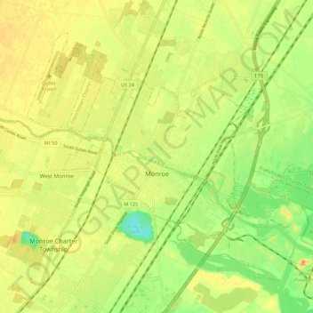
Name: Monroe topographic map, elevation, terrain.
Location: Monroe, Monroe County, Michigan, United States (41.88681 -83.44217 41.95087 -83.33374)
Average elevation: 597 ft
Minimum elevation: 515 ft
Maximum elevation: 656 ft
According to the United States Census Bureau, the city has a total area of 10.18 square miles (26.37 km2), of which 9.17 square miles (23.75 km2) is land and 1.01 square miles (2.62 km2) (9.92%) is water. Monroe sits at the lowest elevation in state of Michigan, which is the shores of Lake Erie at 571 feet (174 meters). The average elevation of the city of Monroe is 594 feet (181 meters). The Port of Monroe is the only Michigan port on Lake Erie, and Sterling State Park is the only of Michigan's 103 state parks located on or near Lake Erie. The River Raisin and Sandy Creek travel through Monroe; they are non-navigable because of the several dams and other obstructions.
Other topographic maps
Click on a map to view its topography, its elevation and its terrain.
London Township
United States > Michigan > Monroe County
London Township, Monroe County, Michigan, 48159, United States
Average elevation: 659 ft
Petersburg
United States > Michigan > Monroe County
Petersburg, Monroe County, Michigan, United States
Average elevation: 676 ft
Dundee Township
United States > Michigan > Monroe County
Dundee Township, Monroe County, Michigan, 48131, United States
Average elevation: 659 ft
Stony Point
United States > Michigan > Monroe County
Stony Point, Monroe County, Michigan, United States
Average elevation: 568 ft
Exeter Township
United States > Michigan > Monroe County
Exeter Township, Monroe County, Michigan, United States
Average elevation: 630 ft
Erie Township
United States > Michigan > Monroe County
Erie Township, Monroe County, Michigan, 48133, United States
Average elevation: 591 ft
Summerfield Township
United States > Michigan > Monroe County
Summerfield Township, Monroe County, Michigan, 49270, United States
Average elevation: 676 ft
Ash Township
United States > Michigan > Monroe County
Ash Township, Monroe County, Michigan, 48117, United States
Average elevation: 607 ft
Berlin Charter Township
United States > Michigan > Monroe County
Berlin Charter Township, Monroe County, Michigan, 48179, United States
Average elevation: 584 ft
Dundee
United States > Michigan > Monroe County > Dundee Township
Dundee, Dundee Township, Monroe County, Michigan, 48131, United States
Average elevation: 663 ft
Berlin Township
United States > Michigan > Monroe County > Berlin Township > Berlin Township
Berlin Township, Monroe County, Michigan, 48179, United States
Average elevation: 581 ft