
Cadillac topographic map
Interactive map
Click on the map to display elevation.
About this map
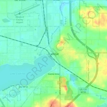
Name: Cadillac topographic map, elevation, terrain.
Location: Cadillac, Wexford County, Michigan, United States (44.22294 -85.45675 44.28132 -85.37623)
Average elevation: 1,325 ft
Minimum elevation: 1,270 ft
Maximum elevation: 1,486 ft
Other topographic maps
Click on a map to view its topography, its elevation and its terrain.
Buckley
United States > Michigan > Wexford County
Buckley, Hanover Township, Wexford County, Michigan, 49620, United States
Average elevation: 1,040 ft
Manton
United States > Michigan > Wexford County
Manton, Wexford County, Michigan, United States
Average elevation: 1,138 ft
Mesick
United States > Michigan > Wexford County
Mesick, Springville Township, Wexford County, Michigan, United States
Average elevation: 912 ft
Hanover Township
United States > Michigan > Wexford County
Hanover Township, Wexford County, Michigan, 49620, United States
Average elevation: 978 ft
Boon
United States > Michigan > Wexford County
Boon, Boon Township, Wexford County, Michigan, 49618, United States
Average elevation: 1,394 ft