
Kefalonia topographic map
Interactive map
Click on the map to display elevation.
About this map
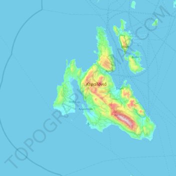
Name: Kefalonia topographic map, elevation, terrain.
Average elevation: 197 ft
Minimum elevation: -3 ft
Maximum elevation: 5,253 ft
Other topographic maps
Click on a map to view its topography, its elevation and its terrain.
Cephalonia
Greece > Peloponnese, Western Greece and the Ionian > Kefallonia Regional Unit
Cephalonia, Kefallonia Regional Unit, Ioanian Islands, Peloponnese, Western Greece and the Ionian, Greece
Average elevation: 453 ft
Antipata
Greece > Peloponnese, Western Greece and the Ionian > Kefallonia Regional Unit > Pylaros Municipal Unit > Antipata
Antipata, Pylaros Municipal Unit, Sami Municipality, Kefallonia Regional Unit, Ioanian Islands, Peloponnese, Western Greece and the Ionian, 28081, Greece
Average elevation: 1,270 ft