
Denbigh topographic map
Interactive map
Click on the map to display elevation.
About this map
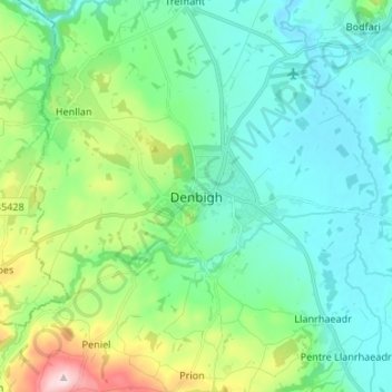
Name: Denbigh topographic map, elevation, terrain.
Location: Denbigh, Denbighshire, Wales, LL16 3UN, United Kingdom (53.14538 -3.45783 53.22538 -3.37783)
Average elevation: 335 ft
Minimum elevation: 69 ft
Maximum elevation: 1,227 ft
Other topographic maps
Click on a map to view its topography, its elevation and its terrain.
Y Berwyn National Nature Reserve
United Kingdom > Wales > Denbighshire
Y Berwyn National Nature Reserve, Llandrillo, Denbighshire, Wales, LL21 0TE, United Kingdom
Average elevation: 1,493 ft
Prestatyn
United Kingdom > Wales > Denbighshire
Prestatyn, Denbighshire, Wales, LL19 9LG, United Kingdom
Average elevation: 157 ft
Aberwheeler
United Kingdom > Wales > Denbighshire > Bodfari
Aberwheeler, Bodfari, Denbighshire, Wales, LL16 4BT, United Kingdom
Average elevation: 318 ft
Corwen
United Kingdom > Wales > Denbighshire
Corwen, Denbighshire, Wales, LL21 0DL, United Kingdom
Average elevation: 899 ft
Ruthin
United Kingdom > Wales > Denbighshire > Ruthin
Ruthin, Denbighshire, Wales, LL15 1BU, United Kingdom
Average elevation: 531 ft