
Solok topographic map
Interactive map
Click on the map to display elevation.
About this map
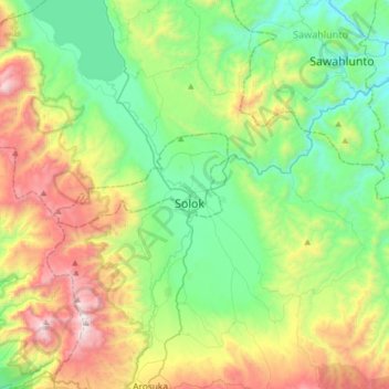
Name: Solok topographic map, elevation, terrain.
Location: Solok, West Sumatra, Indonesia (-0.95222 100.49733 -0.63222 100.81733)
Average elevation: 2,411 ft
Minimum elevation: 636 ft
Maximum elevation: 6,161 ft
Solok (means valley) is a city in West Sumatra, Indonesia. Its motto is Kota Beras, abbreviation from "Bersih, Elok, Rapi, Aman dan Sejahtera". It has an area of 57.64 km² (0.14 percent of the area of West Sumatra) and a population of 69,776 people in 2018. Solok topography varies between the plains and hilly with a height of 390 m above sea level. There are three tributaries that cross Solok, namely Batang Lembang, Batang Gawan, and Batang Air Binguang.