
West Falkland topographic map
Interactive map
Click on the map to display elevation.
About this map
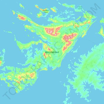
Name: West Falkland topographic map, elevation, terrain.
Location: West Falkland, Islas Malvinas, Falkland Islands (-52.26002 -61.07953 -51.33567 -59.19274)
Average elevation: 105 ft
Minimum elevation: -3 ft
Maximum elevation: 2,251 ft
Other topographic maps
Click on a map to view its topography, its elevation and its terrain.
Port Howard
Falkland Islands > Port Howard > Port Howard
Port Howard, Islas Malvinas, Falkland Islands
Average elevation: 148 ft