
Garden City topographic map
Interactive map
Click on the map to display elevation.
About this map
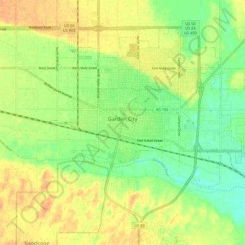
Name: Garden City topographic map, elevation, terrain.
Location: Garden City, Finney County, Kansas, 67846, United States (37.93694 -100.90168 38.00357 -100.79251)
Average elevation: 2,854 ft
Minimum elevation: 2,795 ft
Maximum elevation: 2,907 ft
Garden City is at 37°58′31″N 100°51′51″W / 37.97528°N 100.86417°W / 37.97528; -100.86417 at an elevation of 2,838 feet (865 m). The city lies on the north side of the Arkansas River in the High Plains region of the Great Plains. It is located in southwestern Kansas at the intersection of U.S. Route 50 and U.S. Route 83, Garden City is 192 miles (309 km) west-northwest of Wichita, 204 miles (328 km) north-northeast of Amarillo, and 255 miles (410 km) southeast of Denver. According to the United States Census Bureau, the city has a total area of 8.82 square miles (22.84 km2), all land. It is the most remote city in America with population over 25,000.
Other topographic maps
Click on a map to view its topography, its elevation and its terrain.
Plymell
United States > Kansas > Finney County
Plymell, Finney County, Kansas, United States
Average elevation: 2,881 ft
Holcomb
United States > Kansas > Finney County
Holcomb, Finney County, Kansas, United States
Average elevation: 2,884 ft
Pierceville
United States > Kansas > Finney County
Pierceville, Finney County, Kansas, 67868, United States
Average elevation: 2,782 ft
Ravanna
United States > Kansas > Finney County > Ravanna
Ravanna, Finney County, Kansas, United States
Average elevation: 2,566 ft
Garden City
United States > Kansas > Finney County > Garden City > Garden City
Garden City, Finney County, Kansas, 67846-5440, United States
Average elevation: 2,894 ft