
Caura topographic map
Interactive map
Click on the map to display elevation.
About this map
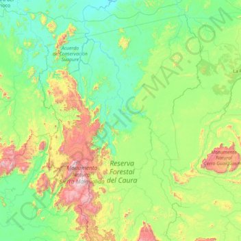
Name: Caura topographic map, elevation, terrain.
Location: Caura, Sucre Municipality, Bolívar, Venezuela (4.88332 -65.21936 7.64950 -64.41821)
Average elevation: 1,188 ft
Minimum elevation: 49 ft
Maximum elevation: 7,503 ft
Other topographic maps
Click on a map to view its topography, its elevation and its terrain.
Ptari Tepui
Venezuela > Bolívar > Parroquia Sección Capital Gran Sabana
Ptari Tepui, Parroquia Sección Capital Gran Sabana, Gran Sabana Municipality, Bolívar, Venezuela
Average elevation: 6,243 ft
Villa Betania
Venezuela > Bolívar > Ciudad Guayana (Puerto Ordaz)
Villa Betania, Ciudad Guayana (Puerto Ordaz), Parroquia Unare, Distrito Caroní, Bolívar, Venezuela
Average elevation: 361 ft