
Sinharaja Forest Reserve topographic map
Interactive map
Click on the map to display elevation.
About this map
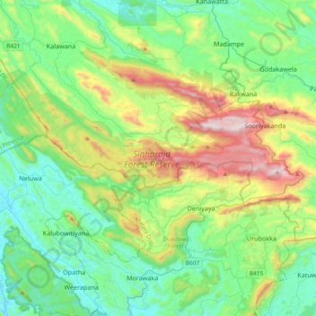
Name: Sinharaja Forest Reserve topographic map, elevation, terrain.
Average elevation: 1,237 ft
Minimum elevation: 36 ft
Maximum elevation: 4,442 ft
Other topographic maps
Click on a map to view its topography, its elevation and its terrain.
Pothupitiya
Sri Lanka > Sabaragamuwa Province > Pothupitiya
Pothupitiya, Ratnapura District, Sabaragamuwa Province, Sri Lanka
Average elevation: 1,719 ft