
Ballari topographic map
Interactive map
Click on the map to display elevation.
About this map
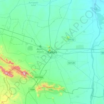
Name: Ballari topographic map, elevation, terrain.
Average elevation: 1,542 ft
Minimum elevation: 1,280 ft
Maximum elevation: 3,166 ft
Other topographic maps
Click on a map to view its topography, its elevation and its terrain.
Joladarshi
India > Karnataka > Bellary taluk
Joladarshi, Bellary taluk, Bellary district, Karnataka, 583111, India
Average elevation: 1,434 ft