
Futrono topographic map
Interactive map
Click on the map to display elevation.
About this map
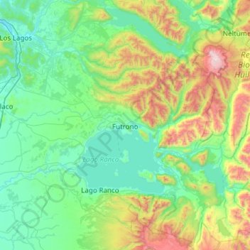
Name: Futrono topographic map, elevation, terrain.
Average elevation: 1,535 ft
Minimum elevation: 49 ft
Maximum elevation: 7,861 ft
Other topographic maps
Click on a map to view its topography, its elevation and its terrain.
Zona Sur
Chile > Los Ríos Region > Provincia de Ranco > Río Bueno
Zona Sur, Río Bueno, Provincia de Ranco, Los Ríos Region, Chile
Average elevation: 1,309 ft