
Νέα Χηλή topographic map
Interactive map
Click on the map to display elevation.
About this map
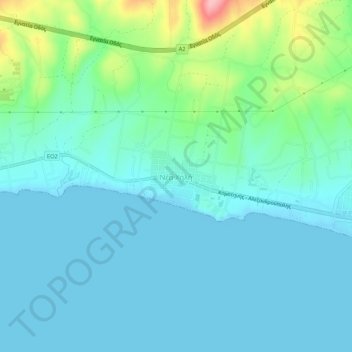
Name: Νέα Χηλή topographic map, elevation, terrain.
Average elevation: 89 ft
Minimum elevation: -7 ft
Maximum elevation: 463 ft
Other topographic maps
Click on a map to view its topography, its elevation and its terrain.
Samothraki
Greece > Macedonia and Thrace > Evros Regional Unit
Samothraki, Evros Regional Unit, Eastern Macedonia and Thrace, Macedonia and Thrace, 680 02, Greece
Average elevation: 558 ft