
Wilcote topographic map
Interactive map
Click on the map to display elevation.
About this map
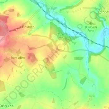
Name: Wilcote topographic map, elevation, terrain.
Average elevation: 384 ft
Minimum elevation: 246 ft
Maximum elevation: 561 ft
Other topographic maps
Click on a map to view its topography, its elevation and its terrain.
Alvescot
United Kingdom > England > Oxfordshire > West Oxfordshire
Alvescot, West Oxfordshire, Oxfordshire, England, United Kingdom
Average elevation: 285 ft
Lew
United Kingdom > England > Oxfordshire > West Oxfordshire
Lew, West Oxfordshire, Oxfordshire, England, United Kingdom
Average elevation: 259 ft
Ramsden
United Kingdom > England > Oxfordshire > West Oxfordshire
Ramsden, West Oxfordshire, Oxfordshire, England, United Kingdom
Average elevation: 446 ft
Cassington
United Kingdom > England > Oxfordshire > West Oxfordshire > Cassington
Cassington, West Oxfordshire, Oxfordshire, England, United Kingdom
Average elevation: 236 ft
Mount Skippett
United Kingdom > England > Oxfordshire > West Oxfordshire > Ramsden
Mount Skippett, Ramsden, West Oxfordshire, Oxfordshire, England, OX7 3AP, United Kingdom
Average elevation: 443 ft
Standlake
United Kingdom > England > Oxfordshire > West Oxfordshire
Standlake, West Oxfordshire, Oxfordshire, England, United Kingdom
Average elevation: 220 ft
Shipton-under-Wychwood
United Kingdom > England > Oxfordshire > West Oxfordshire
Shipton-under-Wychwood, West Oxfordshire, Oxfordshire, England, OX7 6DE, United Kingdom
Average elevation: 430 ft
Chadlington
United Kingdom > England > Oxfordshire > West Oxfordshire
Chadlington, West Oxfordshire, Oxfordshire, England, United Kingdom
Average elevation: 528 ft
Windrush
United Kingdom > England > Oxfordshire > West Oxfordshire > Witney
Windrush, Witney, West Oxfordshire, Oxfordshire, South East England, England, OX28 4DG, United Kingdom
Average elevation: 285 ft
Burford
United Kingdom > England > Oxfordshire > West Oxfordshire > Fulbrook
Burford, Fulbrook, West Oxfordshire, Oxfordshire, England, United Kingdom
Average elevation: 423 ft
Woodstock
United Kingdom > England > Oxfordshire > West Oxfordshire > Woodstock
Woodstock, West Oxfordshire, Oxfordshire, South East England, England, United Kingdom
Average elevation: 315 ft
Brize Norton
United Kingdom > England > Oxfordshire > West Oxfordshire
Brize Norton, West Oxfordshire, Oxfordshire, England, United Kingdom
Average elevation: 318 ft
Enstone
United Kingdom > England > Oxfordshire > West Oxfordshire
Enstone, West Oxfordshire, Oxfordshire, England, United Kingdom
Average elevation: 525 ft
Chipping Norton
United Kingdom > England > Oxfordshire > West Oxfordshire > Chipping Norton
Chipping Norton, West Oxfordshire, Oxfordshire, England, United Kingdom
Average elevation: 636 ft
Stanton Harcourt
United Kingdom > England > Oxfordshire > West Oxfordshire > Stanton Harcourt
Stanton Harcourt, West Oxfordshire, Oxfordshire, England, United Kingdom
Average elevation: 220 ft
Kingham
United Kingdom > England > Oxfordshire > West Oxfordshire
Kingham, West Oxfordshire, Oxfordshire, England, United Kingdom
Average elevation: 427 ft
Eynsham
United Kingdom > England > Oxfordshire > West Oxfordshire
Eynsham, West Oxfordshire, Oxfordshire, England, United Kingdom
Average elevation: 246 ft
Lyneham
United Kingdom > England > Oxfordshire > West Oxfordshire
Lyneham, West Oxfordshire, Oxfordshire, England, United Kingdom
Average elevation: 427 ft
Witney
United Kingdom > England > Oxfordshire > West Oxfordshire
Witney, West Oxfordshire, Oxfordshire, England, United Kingdom
Average elevation: 302 ft
Taynton
United Kingdom > England > Oxfordshire > West Oxfordshire
Taynton, West Oxfordshire, Oxfordshire, England, United Kingdom
Average elevation: 499 ft