
Senatobia topographic map
Interactive map
Click on the map to display elevation.
About this map
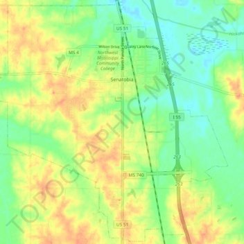
Name: Senatobia topographic map, elevation, terrain.
Location: Senatobia, Tate County, Mississippi, 38668, United States (34.56626 -90.02170 34.64177 -89.92789)
Average elevation: 289 ft
Minimum elevation: 223 ft
Maximum elevation: 358 ft
Other topographic maps
Click on a map to view its topography, its elevation and its terrain.
Bett
United States > Mississippi > Tate County
Bett, Tate County, Mississippi, United States
Average elevation: 348 ft