
Gila Wilderness topographic map
Interactive map
Click on the map to display elevation.
About this map
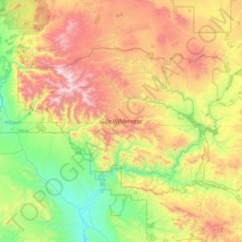
Name: Gila Wilderness topographic map, elevation, terrain.
Location: Gila Wilderness, Catron County, New Mexico, United States (33.00793 -108.81918 33.41853 -108.00968)
Average elevation: 6,841 ft
Minimum elevation: 4,396 ft
Maximum elevation: 10,915 ft
The Gila Wilderness is located in southwest New Mexico, north of Silver City and east of Reserve. It contains the West Fork, Middle Fork and much of the East Fork of the Gila River; riverside elevations of around 4,850 feet (1,480 m) are the lowest in the wilderness. The Mogollon Mountains traverse an arc across the wilderness. The tallest peak within this range, Whitewater Baldy at 10,895 ft (3,321 m), is in the northwest part of the wilderness along with several other summits more than 10,000 ft (3,048 m) high. At the northeast corner is prominent Black Mountain rising to 9,287 ft (2,831 m). The Gila Cliff Dwellings National Monument is adjacent to the wilderness.
Other topographic maps
Click on a map to view its topography, its elevation and its terrain.
Prairie Lake
United States > New Mexico > Catron County
Prairie Lake, Catron County, New Mexico, United States
Average elevation: 7,684 ft
San Francisco
United States > New Mexico > Catron County
San Francisco, Catron County, New Mexico, United States
Average elevation: 8,005 ft
Quemado
United States > New Mexico > Catron County
Quemado, Catron County, New Mexico, United States
Average elevation: 6,932 ft
Alma
United States > New Mexico > Catron County
Alma, Catron County, New Mexico, United States
Average elevation: 5,036 ft
Capital Dome
United States > New Mexico > Catron County
Capital Dome, Catron County, New Mexico, United States
Average elevation: 8,068 ft
Cruzville
United States > New Mexico > Catron County
Cruzville, Catron County, New Mexico, United States
Average elevation: 6,480 ft
Reserve
United States > New Mexico > Catron County
Reserve, Catron County, New Mexico, United States
Average elevation: 5,840 ft
Datil
United States > New Mexico > Catron County
Datil, Catron County, New Mexico, United States
Average elevation: 7,477 ft
San Francisco Mountains
United States > New Mexico > Catron County
San Francisco Mountains, Catron County, New Mexico, United States
Average elevation: 8,337 ft
Pie Town
United States > New Mexico > Catron County
Pie Town, Catron County, New Mexico, 87827, United States
Average elevation: 7,717 ft