
Antelope Island topographic map
Interactive map
Click on the map to display elevation.
About this map
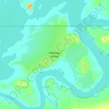
Name: Antelope Island topographic map, elevation, terrain.
Average elevation: 3,730 ft
Minimum elevation: 3,625 ft
Maximum elevation: 4,298 ft
Other topographic maps
Click on a map to view its topography, its elevation and its terrain.
Navajo Viewpoint
United States > Arizona > Coconino County > Wahweap
Navajo Viewpoint, Lake Shore Drive, Wahweap, Coconino County, Arizona, United States
Average elevation: 3,862 ft