
Valdosta topographic map
Interactive map
Click on the map to display elevation.
About this map
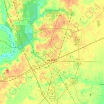
Name: Valdosta topographic map, elevation, terrain.
Location: Valdosta, Lowndes County, Georgia, United States (30.76171 -83.34451 30.92885 -83.22193)
Average elevation: 190 ft
Minimum elevation: 98 ft
Maximum elevation: 279 ft
Other topographic maps
Click on a map to view its topography, its elevation and its terrain.
Lake Park
United States > Georgia > Lowndes County
Lake Park, Lowndes County, Georgia, 31636, United States
Average elevation: 154 ft
Naylor
United States > Georgia > Lowndes County
Naylor, Lowndes County, Georgia, United States
Average elevation: 184 ft
Valdosta
United States > Georgia > Lowndes County > Valdosta
Valdosta, Lowndes County, Georgia, 31604, United States
Average elevation: 177 ft