
Averill Park topographic map
Interactive map
Click on the map to display elevation.
About this map
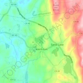
Name: Averill Park topographic map, elevation, terrain.
Average elevation: 807 ft
Minimum elevation: 548 ft
Maximum elevation: 1,260 ft
Other topographic maps
Click on a map to view its topography, its elevation and its terrain.
West Sand Lake
United States > New York > Rensselaer County > Town of Sand Lake
West Sand Lake, Town of Sand Lake, Rensselaer County, New York, 12196, United States
Average elevation: 594 ft
Glass Lake
United States > New York > Rensselaer County > Town of Sand Lake
Glass Lake, Town of Sand Lake, Rensselaer County, New York, 12018, United States
Average elevation: 1,001 ft