
Crawford Notch State Park topographic map
Interactive map
Click on the map to display elevation.
About this map
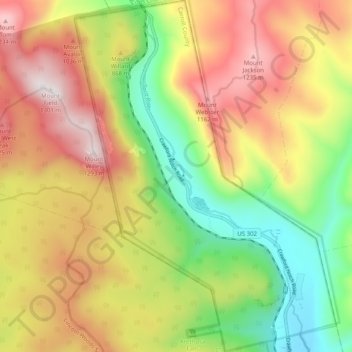
Name: Crawford Notch State Park topographic map, elevation, terrain.
Average elevation: 2,612 ft
Minimum elevation: 1,086 ft
Maximum elevation: 4,262 ft
Other topographic maps
Click on a map to view its topography, its elevation and its terrain.
Sawyers River
United States > New Hampshire > Carroll County > Hart's Location
Sawyers River, Hart's Location, Carroll County, New Hampshire, United States
Average elevation: 1,499 ft
Mount Willard
United States > New Hampshire > Carroll County > Hart's Location
Mount Willard, Hart's Location, Carroll County, New Hampshire, United States
Average elevation: 2,543 ft