
Ifrane topographic map
Interactive map
Click on the map to display elevation.
About this map
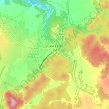
Name: Ifrane topographic map, elevation, terrain.
Average elevation: 5,472 ft
Minimum elevation: 5,033 ft
Maximum elevation: 6,030 ft
Ifrane (Arabic: إفران; Berber languages: ⵉⴼⵔⴰⵏ) is a city in the Middle Atlas region of northern Morocco (population 14,659 as of November 2014). The capital of Ifrane Province in the region of Fès-Meknès, Ifrane is located at an elevation of 1,665 m (5,463 ft). In the regional Tamazight language, "ifran" means caves.