
Smackover topographic map
Interactive map
Click on the map to display elevation.
About this map
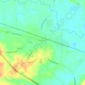
Name: Smackover topographic map, elevation, terrain.
Location: Smackover, Union County, Arkansas, 71762, United States (33.34274 -92.75240 33.38477 -92.71348)
Average elevation: 128 ft
Minimum elevation: 82 ft
Maximum elevation: 217 ft
Other topographic maps
Click on a map to view its topography, its elevation and its terrain.
Junction City
United States > Arkansas > Union County > Junction City, AR
Junction City, Junction City, AR, Union County, Arkansas, 71256, United States
Average elevation: 171 ft
Mount Holly
United States > Arkansas > Union County > Mount Holly
Mount Holly, Union County, Arkansas, United States
Average elevation: 236 ft
Felsenthal
United States > Arkansas > Union County
Felsenthal, Union County, Arkansas, United States
Average elevation: 79 ft
Caledonia
United States > Arkansas > Union County > Caledonia
Caledonia, Union County, Arkansas, United States
Average elevation: 217 ft
El Dorado
United States > Arkansas > Union County
El Dorado, Union County, Arkansas, United States
Average elevation: 217 ft