
Mutasa topographic map
Interactive map
Click on the map to display elevation.
About this map
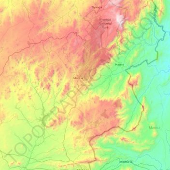
Name: Mutasa topographic map, elevation, terrain.
Location: Mutasa, Manicaland Province, Zimbabwe (-18.97345 32.39750 -18.20112 33.06835)
Average elevation: 4,140 ft
Minimum elevation: 1,742 ft
Maximum elevation: 8,415 ft
Other topographic maps
Click on a map to view its topography, its elevation and its terrain.
Nyanga
Zimbabwe > Manicaland Province
Nyanga, Manicaland Province, Zimbabwe
Average elevation: 3,389 ft
Chipinge
Zimbabwe > Manicaland Province
Chipinge, Manicaland Province, Zimbabwe
Average elevation: 1,749 ft
Mutare
Zimbabwe > Manicaland Province
Mutare, Manicaland Province, Zimbabwe
Average elevation: 3,264 ft