
Burlington topographic map
Interactive map
Click on the map to display elevation.
About this map
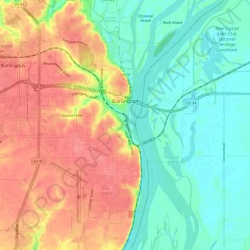
Name: Burlington topographic map, elevation, terrain.
Location: Burlington, Des Moines County, Iowa, 52601, United States (40.76095 -91.18026 40.84766 -91.07838)
Average elevation: 600 ft
Minimum elevation: 505 ft
Maximum elevation: 719 ft
Burlington hosts the Snake Alley Criterium, one of the most physically challenging races in the Midwest. The annual event is held on a 15-block course, with differences in elevation from 555 feet to 678 feet. The course is entirely on city streets, mostly in the downtown commercial area. A one-block-long climb is on the historic brick street named Snake Alley. The 276-foot-long Snake Alley has five switchbacks in a 60-foot climb. The average grade is 12.5 percent in that one block.
Other topographic maps
Click on a map to view its topography, its elevation and its terrain.
Mediapolis
United States > Iowa > Des Moines County
Mediapolis, Des Moines County, Iowa, United States
Average elevation: 771 ft