
Ismailli District topographic map
Interactive map
Click on the map to display elevation.
About this map
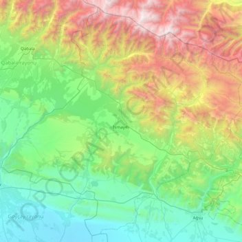
Name: Ismailli District topographic map, elevation, terrain.
Location: Ismailli District, Mountainous Shirvan, Azerbaijan (40.52289 47.76271 41.07772 48.53859)
Average elevation: 3,310 ft
Minimum elevation: 3 ft
Maximum elevation: 11,916 ft
The landscape is mainly composed of mountains. Altitudes vary between 200 and 3629 meters (Babadagh) above sea level. The area is passed by the Goychay, Gyrdyman, Akhokh, Ayrichay, Sulut and other rivers, Yekekhana and Ashygbayram artificial ponds.
Other topographic maps
Click on a map to view its topography, its elevation and its terrain.
Şamaxı
Azerbaijan > Mountainous Shirvan
Şamaxı, Shamakhi District, Mountainous Shirvan, Azerbaijan
Average elevation: 2,375 ft
Sis
Azerbaijan > Mountainous Shirvan
Sis, Shamakhi District, Mountainous Shirvan, Azerbaijan
Average elevation: 3,599 ft
Shamakhi District
Azerbaijan > Mountainous Shirvan
Shamakhi District, Mountainous Shirvan, 5626, Azerbaijan
Average elevation: 2,382 ft
Dəmirçi
Azerbaijan > Mountainous Shirvan
Dəmirçi, Shamakhi District, Mountainous Shirvan, Azerbaijan
Average elevation: 5,072 ft
Mountainous Shirvan
Azerbaijan > Mountainous Shirvan
Mountainous Shirvan, Azerbaijan
Average elevation: 2,333 ft