
Aldershot topographic map
Interactive map
Click on the map to display elevation.
About this map
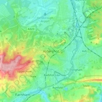
Name: Aldershot topographic map, elevation, terrain.
Average elevation: 302 ft
Minimum elevation: 187 ft
Maximum elevation: 620 ft
Other topographic maps
Click on a map to view its topography, its elevation and its terrain.
Farnborough
United Kingdom > England > Hampshire > Rushmoor
Farnborough, Rushmoor, Hampshire, England, GU14 7JT, United Kingdom
Average elevation: 269 ft