
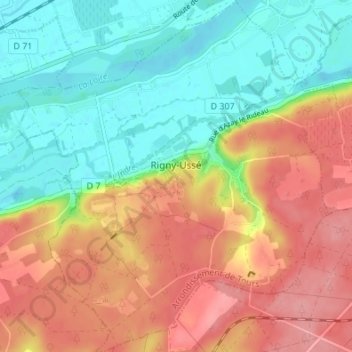
Rigny-Ussé topographic map
Interactive map
Click on the map to display elevation.
About this map
Name: Rigny-Ussé topographic map, elevation, terrain.
Average elevation: 243 ft
Minimum elevation: 98 ft
Maximum elevation: 404 ft
Other topographic maps
Click on a map to view its topography, its elevation and its terrain.
La Vrillonerie
France > Centre-Val de Loire > Indre-et-Loire > Chambray-lès-Tours
La Vrillonerie, Chambray-lès-Tours, Tours, Indre-et-Loire, Centre-Val de Loire, Metropolitan France, 37170, France
Average elevation: 292 ft
Crotelles
France > Centre-Val de Loire > Indre-et-Loire
Crotelles, Loches, Indre-et-Loire, Centre-Val de Loire, Metropolitan France, 37380, France
Average elevation: 427 ft
Tours
France > Centre-Val de Loire > Indre-et-Loire
Tours, Arrondissement de Tours, Indre-et-Loire, Centre-Val de Loire, Metropolitan France, France
Average elevation: 240 ft
Chinon
France > Centre-Val de Loire > Indre-et-Loire
Chinon, Indre-et-Loire, Centre-Val de Loire, Metropolitan France, 37500, France
Average elevation: 190 ft