
Badlands National Park topographic map
Interactive map
Click on the map to display elevation.
About this map
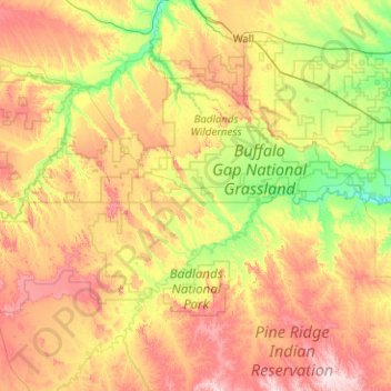
Name: Badlands National Park topographic map, elevation, terrain.
Average elevation: 2,782 ft
Minimum elevation: 2,277 ft
Maximum elevation: 3,596 ft
Other topographic maps
Click on a map to view its topography, its elevation and its terrain.
Red Shirt
United States > South Dakota > Oglala Lakota County
Red Shirt, White Clay District, Oglala Lakota County, South Dakota, United States
Average elevation: 2,772 ft
Porcupine District
United States > South Dakota > Oglala Lakota County
Porcupine District, Oglala Lakota County, South Dakota, 57772, United States
Average elevation: 3,035 ft