
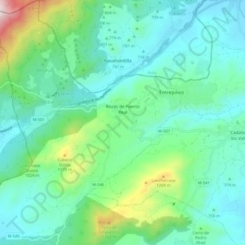
Rozas de Puerto Real topographic map
Interactive map
Click on the map to display elevation.
About this map
Name: Rozas de Puerto Real topographic map, elevation, terrain.
Location: Rozas de Puerto Real, Sierra Oeste, Community of Madrid, Spain (40.26606 -4.55618 40.34491 -4.46664)
Average elevation: 2,795 ft
Minimum elevation: 2,149 ft
Maximum elevation: 5,197 ft
Other topographic maps
Click on a map to view its topography, its elevation and its terrain.
La Castellana y El Pilar
Spain > Community of Madrid > Sierra Oeste > Cadalso de los Vidrios
La Castellana y El Pilar, Cadalso de los Vidrios, Sierra Oeste, Community of Madrid, 28640, Spain
Average elevation: 2,585 ft