
Sun Valley topographic map
Interactive map
Click on the map to display elevation.
About this map
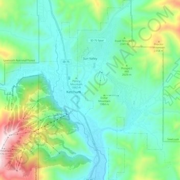
Name: Sun Valley topographic map, elevation, terrain.
Location: Sun Valley, Blaine County, Idaho, United States (43.63996 -114.36125 43.72314 -114.30661)
Average elevation: 6,522 ft
Minimum elevation: 5,656 ft
Maximum elevation: 9,121 ft
Sun Valley is a resort city in the western United States, in Blaine County, Idaho, adjacent to the city of Ketchum in the Wood River valley. The population was 1406 at the 2010 census, down from 1427 in 2000. The elevation of Sun Valley (at the Lodge) is 5,920 feet (1,805 m) above sea level.
Other topographic maps
Click on a map to view its topography, its elevation and its terrain.
Carey
United States > Idaho > Blaine County
Carey, Blaine County, Idaho, 83320, United States
Average elevation: 4,813 ft
Ketchum
United States > Idaho > Blaine County
Ketchum, Blaine County, Idaho, United States
Average elevation: 6,253 ft
Titus Lake
United States > Idaho > Blaine County
Titus Lake, Blaine County, Idaho, United States
Average elevation: 8,976 ft
Bellevue
United States > Idaho > Blaine County
Bellevue, Blaine County, Idaho, 83313, United States
Average elevation: 5,469 ft
Hailey
United States > Idaho > Blaine County
Hailey, Blaine County, Idaho, 83333, United States
Average elevation: 5,673 ft