
Dogiyai topographic map
Interactive map
Click on the map to display elevation.
About this map
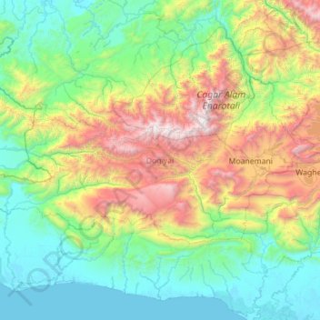
Name: Dogiyai topographic map, elevation, terrain.
Location: Dogiyai, Central Papua, Western New Guinea, Indonesia (-4.29807 135.08396 -3.71159 136.20829)
Average elevation: 2,884 ft
Minimum elevation: -10 ft
Maximum elevation: 12,142 ft
Other topographic maps
Click on a map to view its topography, its elevation and its terrain.
Teluk Cenderawasih National Park
Teluk Cenderawasih National Park, Central Papua, Western New Guinea, Indonesia
Average elevation: 256 ft
Mount Buru
Indonesia > Central Papua > Mimika
Mount Buru, Mimika, Central Papua, Indonesia
Average elevation: 3,327 ft
Mimika
Mimika, Central Papua, Western New Guinea, 99971, Indonesia
Average elevation: 2,119 ft
Puncak Jaya
Indonesia > Central Papua > Mimika
Puncak Jaya, Mimika, Central Papua, Indonesia
Average elevation: 14,012 ft