
Thomasville topographic map
Interactive map
Click on the map to display elevation.
About this map
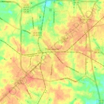
Name: Thomasville topographic map, elevation, terrain.
Location: Thomasville, Thomas County, Georgia, 31792, United States (30.79366 -84.01641 30.87506 -83.93770)
Average elevation: 262 ft
Minimum elevation: 161 ft
Maximum elevation: 322 ft
Other topographic maps
Click on a map to view its topography, its elevation and its terrain.
Fletcherville
United States > Georgia > Thomas County > Thomasville
Fletcherville, Thomasville, Thomas County, Georgia, 31792, United States
Average elevation: 276 ft
Coolidge
United States > Georgia > Thomas County
Coolidge, Thomas County, Georgia, United States
Average elevation: 256 ft
Ochlockonee River
United States > Georgia > Thomas County
Ochlockonee River, Thomas County, Georgia, 31756:31757, United States
Average elevation: 230 ft
Watts Branch
United States > Georgia > Thomas County
Watts Branch, Thomas County, Georgia, 31799, United States
Average elevation: 230 ft