
Bolzano - Bozen topographic map
Interactive map
Click on the map to display elevation.
About this map
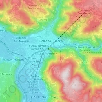
Name: Bolzano - Bozen topographic map, elevation, terrain.
Average elevation: 2,349 ft
Minimum elevation: 725 ft
Maximum elevation: 5,292 ft
The area of the city of Bolzano is 52.3 km2 (20 sq. mi.), of which 28 km2 (10 sq. mi.) is used as a settlement area. The city is located in the basin where the Sarntal, Eisacktal, and the Adige Valley with their rivers, Talfer, Eisack, and Adige, meet. In the Middle Ages, the two main Alpine crossings, the Via Claudia Augusta over Reschenpass and the Brenner route over Brenner Pass, met in Bolzano. Thus, the city was very important for the trade. The highest point is 1616 metres (5302') above sea level and the lowest point is 232 metres (761') above sea level. The center is located at an altitude of 262 metres (860') above sea level. The nearest big cities are 58 km (36 miles) (Trento) and 118 km (73 miles) (Innsbruck) away.