
Piraeus topographic map
Interactive map
Click on the map to display elevation.
About this map
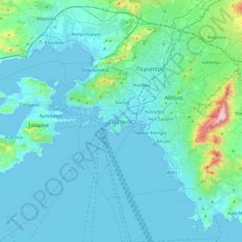
Name: Piraeus topographic map, elevation, terrain.
Average elevation: 315 ft
Minimum elevation: -10 ft
Maximum elevation: 3,340 ft
Other topographic maps
Click on a map to view its topography, its elevation and its terrain.
Municipal Unit of Nikaia
Greece > Attica > Regional Unit of Piraeus
Municipal Unit of Nikaia, Municipality of Nikaia-Agios Ioannis Rentis, Regional Unit of Piraeus, Attica, Greece
Average elevation: 312 ft
Λιμένας Λέοντος
Greece > Attica > Regional Unit of Piraeus > Piraeus > Δραπετσώνα
Λιμένας Λέοντος, Δραπετσώνα, Piraeus, Regional Unit of Piraeus, Attica, Greece
Average elevation: 39 ft