
Boguchwała topographic map
Interactive map
Click on the map to display elevation.
About this map
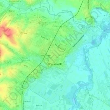
Name: Boguchwała topographic map, elevation, terrain.
Average elevation: 715 ft
Minimum elevation: 653 ft
Maximum elevation: 856 ft
Other topographic maps
Click on a map to view its topography, its elevation and its terrain.
Głogów Małopolski
Poland > Subcarpathian Voivodeship > Rzeszów County
Głogów Małopolski, gmina Głogów Małopolski, Rzeszów County, Subcarpathian Voivodeship, 36-060, Poland
Average elevation: 738 ft