
Romayor topographic map
Interactive map
Click on the map to display elevation.
About this map
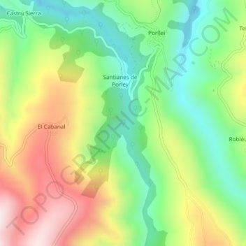
Name: Romayor topographic map, elevation, terrain.
Location: Romayor, Cangas del Narcea, Asturias, Spain (43.16452 -6.47598 43.18452 -6.45598)
Average elevation: 2,379 ft
Minimum elevation: 1,568 ft
Maximum elevation: 3,517 ft
Other topographic maps
Click on a map to view its topography, its elevation and its terrain.
Chagos
Spain > Asturias > Cangas del Narcea > Ḷḷarón > La Vilieḷḷa
Chagos, La Vilieḷḷa, Ḷḷarón, Cangas del Narcea, Asturias, 33811, Spain
Average elevation: 3,143 ft
Siecha
Spain > Asturias > Cangas del Narcea
Siecha, Cangas del Narcea, Asturias, Spain
Average elevation: 2,927 ft