
Mer de Glace topographic map
Interactive map
Click on the map to display elevation.
About this map
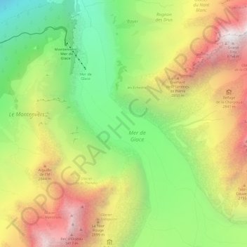
Name: Mer de Glace topographic map, elevation, terrain.
Average elevation: 7,615 ft
Minimum elevation: 4,009 ft
Maximum elevation: 11,778 ft
The glacier lies above the Chamonix valley. The pressure within the ice is known to reach at least 30 atmospheres. The Mer de Glace can be considered as originating at an elevation of 2,100 metres (6,900 ft), just north of the Aiguille du Tacul, where it is formed by the confluence of the Glacier de Leschaux and the Glacier du Tacul. The former is fed by the Glacier du Talefre, whilst the latter is, in turn, fed by the Glacier des Periardes, the vast Glacier du Géant and the broad icefields of the Vallee Blanche. The Glacier du Tacul supplies much more ice than the Glacier de Leschaux.: 20
Other topographic maps
Click on a map to view its topography, its elevation and its terrain.
Chamonix-Mont-Blanc
France > Auvergne-Rhône-Alpes > Upper Savoy > Chamonix-Mont-Blanc > Chamonix-Mont-Blanc
Chamonix-Mont-Blanc, Bonneville, Upper Savoy, Auvergne-Rhône-Alpes, Metropolitan France, 74400, France
Average elevation: 5,863 ft
Aiguille du Midi
France > Auvergne-Rhône-Alpes > Upper Savoy > Chamonix-Mont-Blanc
Aiguille du Midi, Chamonix-Mont-Blanc, Bonneville, Upper Savoy, Auvergne-Rhône-Alpes, Metropolitan France, 74400, France
Average elevation: 10,161 ft
Refuge de L'Envers des Aiguilles
France > Auvergne-Rhône-Alpes > Upper Savoy > Chamonix-Mont-Blanc
Refuge de L'Envers des Aiguilles, Les Balcons de la Mer de Glace, Chamonix-Mont-Blanc, Bonneville, Upper Savoy, Auvergne-Rhône-Alpes, Metropolitan France, 74400, France
Average elevation: 8,356 ft
Aiguille Verte
France > Auvergne-Rhône-Alpes > Upper Savoy > Chamonix-Mont-Blanc
Aiguille Verte, Chamonix-Mont-Blanc, Bonneville, Upper Savoy, Auvergne-Rhône-Alpes, Metropolitan France, 74400, France
Average elevation: 10,577 ft