
Centerville topographic map
Interactive map
Click on the map to display elevation.
About this map
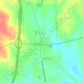
Name: Centerville topographic map, elevation, terrain.
Location: Centerville, Leon County, Texas, United States (31.24423 -95.99166 31.27356 -95.96738)
Average elevation: 358 ft
Minimum elevation: 269 ft
Maximum elevation: 502 ft
Other topographic maps
Click on a map to view its topography, its elevation and its terrain.
Normangee
United States > Texas > Leon County
Normangee, Leon County, Texas, United States
Average elevation: 387 ft
Leona
United States > Texas > Leon County
Leona, Leon County, Texas, United States
Average elevation: 341 ft
Marquez
United States > Texas > Leon County > Marquez
Marquez, Leon County, Texas, United States
Average elevation: 407 ft
Normangee Dam
United States > Texas > Leon County
Normangee Dam, Leon County, Texas, 77871, United States
Average elevation: 341 ft
Buffalo
United States > Texas > Leon County
Buffalo, Leon County, Texas, 75831, United States
Average elevation: 364 ft
Jewett
United States > Texas > Leon County
Jewett, Leon County, Texas, United States
Average elevation: 472 ft