
Lymington and Pennington topographic map
Interactive map
Click on the map to display elevation.
About this map
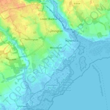
Name: Lymington and Pennington topographic map, elevation, terrain.
Average elevation: 30 ft
Minimum elevation: -16 ft
Maximum elevation: 115 ft
Other topographic maps
Click on a map to view its topography, its elevation and its terrain.
Martin
United Kingdom > England > New Forest
Martin, New Forest, Hampshire, South East, England, United Kingdom
Average elevation: 338 ft
Fordingbridge
United Kingdom > England > New Forest
Fordingbridge, New Forest, Hampshire, South East, England, United Kingdom
Average elevation: 151 ft
Totton and Eling
United Kingdom > England > New Forest
Totton and Eling, New Forest, Hampshire, South East, England, United Kingdom
Average elevation: 43 ft
Copythorne
United Kingdom > England > New Forest
Copythorne, New Forest, Hampshire, South East, England, United Kingdom
Average elevation: 118 ft