
قصرهلال topographic map
Interactive map
Click on the map to display elevation.
About this map
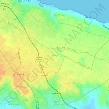
Name: قصرهلال topographic map, elevation, terrain.
Location: قصرهلال, قصر هلال, Monastir, 5070, Tunisia (35.63844 10.87383 35.66483 10.92503)
Average elevation: 59 ft
Minimum elevation: -10 ft
Maximum elevation: 108 ft
Other topographic maps
Click on a map to view its topography, its elevation and its terrain.
Ksar Hellal
Tunisia > Monastir > قصر هلال > Ksar Hellal
Ksar Hellal, قصر هلال, معتمدية قصر هلال, Monastir, 5070, Tunisia
Average elevation: 43 ft