
Nyaruguru topographic map
Interactive map
Click on the map to display elevation.
About this map
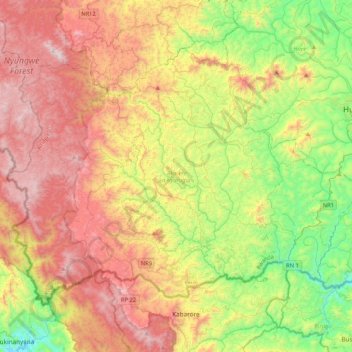
Name: Nyaruguru topographic map, elevation, terrain.
Location: Nyaruguru, Southern Province, Rwanda (-2.83898 29.32765 -2.53124 29.74740)
Average elevation: 6,532 ft
Minimum elevation: 4,518 ft
Maximum elevation: 8,983 ft
Other topographic maps
Click on a map to view its topography, its elevation and its terrain.
Rubona
Rwanda > Southern Province > Huye > Rusatira
Rubona, Rusatira, Huye, Southern Province, Rwanda
Average elevation: 5,364 ft
Kibeho
Rwanda > Southern Province > Nyaruguru District
Kibeho, Nyaruguru District, Southern Province, Rwanda
Average elevation: 6,155 ft
Gatare
Rwanda > Southern Province > Nyamagabe
Gatare, Nyamagabe, Southern Province, Rwanda
Average elevation: 7,169 ft
Rubyiro
Rwanda > Southern Province > Nyamagabe > Buruhukiro
Rubyiro, Buruhukiro, Nyamagabe, Southern Province, Rwanda
Average elevation: 7,917 ft
Mbuye
Rwanda > Southern Province > Ruhango
Mbuye, Ruhango, Southern Province, Rwanda
Average elevation: 5,213 ft
Huye
Rwanda > Southern Province > Huye > Ngoma
Huye, Ngoma, Huye, Southern Province, Rwanda
Average elevation: 5,463 ft
Nyaruguru
Rwanda > Southern Province > Nyaruguru District > Munini
Nyaruguru, Munini, Nyaruguru District, Southern Province, Rwanda
Average elevation: 6,207 ft
Kigoma
Rwanda > Southern Province > Kigoma
Kigoma, Huye, Southern Province, Rwanda
Average elevation: 5,640 ft