
Copeland Forest topographic map
Interactive map
Click on the map to display elevation.
About this map
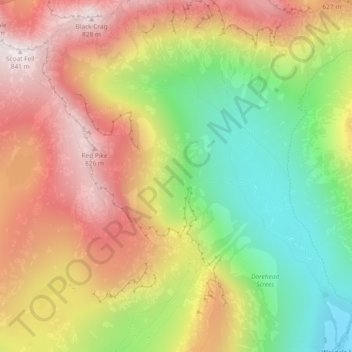
Name: Copeland Forest topographic map, elevation, terrain.
Average elevation: 1,532 ft
Minimum elevation: 259 ft
Maximum elevation: 2,753 ft
Other topographic maps
Click on a map to view its topography, its elevation and its terrain.
St. Bees
United Kingdom > England > Copeland > St Bees
St. Bees, St Bees, Copeland, Cumbria, North West England, England, United Kingdom
Average elevation: 164 ft
Haile
United Kingdom > England > Copeland > Haile
Haile, Copeland, Cumbria, North West England, England, CA22 2ND, United Kingdom
Average elevation: 341 ft